
THE MOST IMPORTANT DATA ON EARTH Available Here in Palisades, for Free
Oceans cover 139 million square miles of the Earth’s surface. They hold the key to understanding our future as global warming escalates. Ironically, scientists know much more about distant planets than they do about the watery depths of our own world.
Collecting data about what is happening underwater is extraordinarily hard and correspondingly expensive. As depth and pressure increase, the dark and forbidding world blocks light and radio waves. Compared with a chatty inter-planetary satellite on a million-mile journey, a Navy submarine just a few hundred feet underwater off Block Island cannot send a signal of any kind to home base in Groton without coming to the surface.
Undaunted by the massive scale of the problem, Lamont Doherty Earth Observatory scientists joined the World Ocean Circulation Experiment in 1989, which was handed off to the GO-SHIP.org project eight years ago. This international consortium includes the National Science Foundation, NOAA, and government agencies from a half dozen other countries cooperating to build a usable data set so that scientists can track what’s going on at all depths in all seven oceans.
For thirty years, a small fleet of ships run primarily by the United States, Japan, Germany, and Australia has been crisscrossing the globe along a pre-set grid from the Antarctic to the top of Greenland to collect samples and data. Passing over continental shelves, the vessels sail high above ridges of underwater volcanoes and sea-floor rift zones, peering into the dark unmoving waters of the abyssal plains and even part of the way into the trenches. The instruments reach their depth limit at 6,000 meters (19,600 feet), which is enough to cover 98 percent of the ocean.
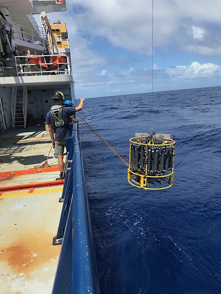
Last June, Lamont’s Andreas Thurnherr was the lead scientist on a GO-SHIP expedition from Honolulu to San Diego. He spent 33 days at sea with about 30 scientists and technicians on the research vessel Revelle, (named after one of the earliest climate scientists, oceanographer Roger Revelle of UC San Diego). Thurnherr came to physical oceanography almost by accident. Back in the 1980s, while driving near his home in Zurich, he picked up two hitchhikers. As fate would have it, they were marine biologists. Their tantalizing conversation inspired the recent computer engineering grad to abandon job offers from several earthbound Swiss banks and move to the Caribbean coast of Honduras. He became a skilled scuba diver and coral reef guide, and later pursued his love of the ocean to its next logical step, pursuing graduate studies in the UK. He is now a research professor at Columbia University’s Lamont Doherty Earth Observatory.
During Thurnherr’s cruise in June, the Revelle steered a straight course for 2,608 miles across the eastern Pacific, stopping at 97 locations pinpointed by satellite. At each station, they used a cable to lower a two-ton piece of equipment over the side and collected water samples at intervals all the way to the sea floor, guided by pressure, temperature, salt, and oxygen measurements. On-board, scientists and technicians worked around the clock in exhausting 12-hour shifts, testing water samples immediately as they were pulled up onto the deck of the ship. The on-board laboratory generates additional measurements including pH, chlorofluorocarbons (CFCs), nitrous oxide, and nutrients.
The small team of ships run by the international consortium has 139 million square miles to cover. In order to observe change, sensors must be returned to the same spots to generate a timeline. A series of four to five samples from a particular station over thirty years would be the minimum needed for a scientist to say anything about the meaning of the data. It’s been thirty years since the G0-SHIP project began.
So now something can finally be said.

The findings are shocking. Miles below the surface, deep ocean temperatures are rising. The unchanging water at the bottom of the sea has started to change. Closer to the surface, the thickness of warming upper layers is growing.
As expected, temperature trends in the shallow ocean are much more variable. Inevitably, to humans, these changes are much more exciting because potential disruptions to our lives here on land might come so quickly. This uncertainty also makes short term predictions difficult. Twenty years ago, science fiction filmmakers had already learned that a shutdown of the Gulf Stream (part of the Atlantic meridional overturning circulation or AMOC) could, possibly, cause a sudden climate shift. Scriptwriters had New Yorkers freezing to death in a matter of weeks after an AMOC “shutoff” in The Day After Tomorrow. Brisk back and forth analysis on what might actually happen with these surface currents, and when, has injected enough skepticism into the situation so that those who wish to deny the risks might be able to cherry-pick some data to do so. Postponing change in human behavior might still seem possible.
Meanwhile, every day, the vast surface area of the oceans absorbs ninety percent of all the heat energy we emit into the atmosphere, buffering our daily carbon emissions. Over a short human lifespan, the oceans appear to act as a heaven-sent global air-conditioner, but the water is only storing the heat, not eliminating it. Vast as the oceans are, they have a limit. Scientists estimate that this ability to absorb our heat will max out in about 1,000 years if current trends continue. At that point the oceans will stop buffering and start releasing all the stored heat, with unimaginable consequences for life on Earth.
The deep ocean reacts very slowly to change, making its broad trend extremely clear. The rate of gradual warming in the trenches and abyssal depths is steady, and it is irreversible.
Anyone can download GO-SHIP data sets and start analyzing. Unlike any other website you’ve been to recently, users don’t even need to leave a name of e-mail. https://usgoship.ucsd.edu